Hidden mechanical weaknesses within lava domes provided by buried high-porosity hydrothermal alteration zones - PubMed Skip to main page content
U.S. flag

An official website of the United States government

Dot gov

The .gov means it’s official.
Federal government websites often end in .gov or .mil. Before sharing sensitive information, make sure you’re on a federal government site.

Https

The site is secure.
The https:// ensures that you are connecting to the official website and that any information you provide is encrypted and transmitted securely.

Access keys NCBI Homepage MyNCBI Homepage Main Content Main Navigation
. 2022 Feb 25;12(1):3202.
doi: 10.1038/s41598-022-06765-9.

Hidden mechanical weaknesses within lava domes provided by buried high-porosity hydrothermal alteration zones

Affiliations

Hidden mechanical weaknesses within lava domes provided by buried high-porosity hydrothermal alteration zones

Herlan Darmawan et al. Sci Rep. .

Abstract

Catastrophic lava dome collapse is considered an unpredictable volcanic hazard because the physical properties, stress conditions, and internal structure of lava domes are not well understood and can change rapidly through time. To explain the locations of dome instabilities at Merapi volcano, Indonesia, we combined geochemical and mineralogical analyses, rock physical property measurements, drone-based photogrammetry, and geoinformatics. We show that a horseshoe-shaped alteration zone that formed in 2014 was subsequently buried by renewed lava extrusion in 2018. Drone data, as well as geomechanical, mineralogical, and oxygen isotope data suggest that this zone is characterized by high-porosity hydrothermally altered materials that are mechanically weak. We additionally show that the new lava dome is currently collapsing along this now-hidden weak alteration zone, highlighting that a detailed understanding of dome architecture, made possible using the monitoring techniques employed here, is essential for assessing hazards associated with dome and edifice failure at volcanoes worldwide.


Conflict of interest statement

The authors declare no competing interests.

Figures

Figure 1
Figure 1
Merapi volcano. (A) Overview map of Java Island with Central Java marked by black box. (B) View of Merapi volcano from the South. White box marks enlarged area in subsequent image. (C) Merapi summit dome close up photograph showing fumarole activity and ongoing hydrothermal degassing including yellowish coloured alteration zones (1 July 2012). Inset in (C) shows a thermal infrared camera image (handheld camera type: FLIR P 660) that highlights apparent temperature highs located at the southern part of the lava dome (t1 and t2) prior to the 2012–2014 explosions. Mapviews were created using ArcMap (v10.5, https://desktop.arcgis.com/de/arcmap/), FLIR image created using the FLIR ThermaCAM Researcher Pro (vs2.10) software.
Figure 2
Figure 2
Hydrothermal alteration at Merapi summit in 2017. (a) Photomosaic of drone images acquired in 2017 used to map hydrothermal alteration at Merapi summit. No significant deformation was observed between 2015 and 2017, however, many rock falls were deposited at the western and the eastern crater floor area during this period. (b) Map of hydrothermal alteration, structures and active fumaroles at Merapi summit, and the sample location of the Merapi dome rocks that are used in this study (from the 1902 dome lava). (c) The Merapi dome rock samples show different degrees of alteration from fresh to intensely altered, as already identified by their colour changes. Mapviews were created using ArcMap (v10.5) (https://desktop.arcgis.com/de/arcmap/).
Figure 3
Figure 3
Temporal changes at Merapi summit dome. (a) Drone data was processed to generate high resolution orthomosaic representing the Merapi dome in map view (upper row) for 2015 (left) and for 2017 (right). The principle component analysis for PC2 is suggesting an increasing area of hydrothermal alteration. Shadowed regions are not further considered. White box indicates the area of the zoom-in. (b) Zoom-in of the orthomosaic and PCA maps, highlighting for the observed 2-year period, that the degree of steaming and alteration notably increases along the eastern segment of the horseshoe-shaped fracture, as well as at the southern flank of the lava dome. Note that this area has collapsed and is the site of frequent mass wasting events and the origin of pyroclastic density currents during the recent (post 2019) crisis of Merapi volcano. Orthomaps and PCA analysis were created using ArcMap (v10.5) (https://desktop.arcgis.com/de/arcmap/).
Figure 4
Figure 4
Mineralogy of dome lava samples. (a) Pie charts of mineral contents determined by XRD from fresh dome lava (left), moderately altered dome lava (centre) and strongly altered dome lava (right) based on data in Supplementary Table S2. The amount of andesine feldspar (mid- Ca plagioclase) is steadily decreasing while the proportion of alteration minerals (e.g. natro-alunite, gypsum) is seen to increase, documenting progressive replacement of the original rock mass with an acidic sulphurous alteration mineral assemblage. (b) BSE image of a lined vug in the strongly altered dome rock sample. (ce) Chemical element maps (Na, Fe, and S respectively) showing Fe and S enrichment in the secondary minerals that are lining the vesicle, but low Na content relative to primary minerals. The combined mineralogical evidence from XRD and elemental mapping implies that hydrothermal alteration at Merapi progressively replaces strong silicate minerals (e.g. plagioclase) with sulfate mineralization and additional precipitations in fractures and vesicle spaces. While this will progressively reduce porosity of the altered rock, we show that the combined mineralogical changes will cause an overall decrease in the mechanical strength of the dome rock (see Fig. 5).
Figure 5
Figure 5
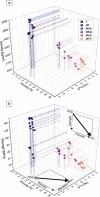
The influence of porosity and hydrothermal alteration on rock strength. (a) Density as a function of porosity (%) and oxygen isotope compositions (δ18O) as a proxy for degree of alteration for the variably-altered rocks collected from the Merapi dome. The unaltered but porous samples from the 2006 eruption are also shown (black symbols; F = fresh). Dotted lines are aids to help visual orientation. (b) Uniaxial compressive strength (MPa) as a function of porosity (%) and oxygen isotope compositions (δ18O) as a proxy for degree of alteration for the variably-altered rocks collected from the Merapi dome. Rock strength decreases as a function of degree of alteration and porosity (see also Supplementary Fig. S1) implying that edifice stability is controlled by a combination of porosity and hydrothermal alteration (see inset). HDS high dome stability, IFI increased flank instability.
Figure 6
Figure 6
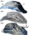
Oblique view of the 3-D rendered model of the Merapi lava dome, imaged by drone cameras in 2012, 2015 and 2019. The thermal anomaly spot (t1) and the horseshoe-shaped fracture in 2012 has given rise to the site of an explosion crater in 2015. A horseshoe-shaped open fissure formed in 2014 and is visible in the image from 2015. The 2019 data show the new lava dome, mantling and burying the earlier dome structures. This new lava dome erupted in 2018 and began to collapse in 2019 along the fracture system that developed in 2014. The total volume of the 2018/19 dome is assumed to have been twice as large as shown by the 2019 image due to frequent material losses. Our data imply that the buried 2014 hydrothermally altered fracture system presently exerts a fundamental control on dome stability and associated rock falls and pyroclastic density currents at Merapi. t1 is a local crater that evolved at the high temperature and alteration area seen in 2012 already (cf. Fig. 1). Oblique views were created in Agisoft Metashape (v1.7) (www.agisoft.com).

Similar articles

Cited by

References

    1. Norton GE, et al. Pyroclastic flow and explosive activity at Soufrière Hills Volcano, Montserrat, during a period of virtually no magma extrusion (March 1998 to November 1999) Geol. Soc. Lond. Memoirs. 2002;21:467–481. doi: 10.1144/GSL.MEM.2002.021.01.21. - DOI
    1. Yamamoto T, Takarada S, Suto S. Pyroclastic flows from the 1991 eruption of Unzen volcano Japan. Bull. Volcanol. 1993;55:166–175. doi: 10.1007/BF00301514. - DOI
    1. Watters RJ, Zimbelman DR, Bowman SD, Crowley JK. Rock mass strength assessment and significance to edifice stability, Mount Rainier and Mount Hood Cascade Range Volcanoes. Pure Appl. Geophys. 2000;157:957–976. doi: 10.1007/s000240050012. - DOI
    1. Reid ME, Sisson TW, Brien DL. Volcano collapse promoted by hydrothermal alteration and edifice shape, Mount Rainier. Wash. Geol. 2002;29:779–782. doi: 10.1130/0091-7613(2001)029<0779:VCPBHA>2.0.CO;2. - DOI
    1. Peruzzetto M, et al. Modeling of partial dome collapse of La Soufrière of Guadeloupe volcano: Implications for hazard assessment and monitoring. Sci. Rep. 2019;9:13105. doi: 10.1038/s41598-019-49507-0. - DOI - PMC - PubMed

Publication types