Temporal and spatial assessments of minimum air temperature using satellite surface temperature measurements in Massachusetts, USA
- PMID: 22721687
- PMCID: PMC4372645
- DOI: 10.1016/j.scitotenv.2012.05.095
Temporal and spatial assessments of minimum air temperature using satellite surface temperature measurements in Massachusetts, USA
Abstract
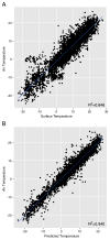
Although meteorological stations provide accurate air temperature observations, their spatial coverage is limited and thus often insufficient for epidemiological studies. Satellite data expand spatial coverage, enhancing our ability to estimate near surface air temperature (Ta). However, the derivation of Ta from surface temperature (Ts) measured by satellites is far from being straightforward. In this study, we present a novel approach that incorporates land use regression, meteorological variables and spatial smoothing to first calibrate between Ts and Ta on a daily basis and then predict Ta for days when satellite Ts data were not available. We applied mixed regression models with daily random slopes to calibrate Moderate Resolution Imaging Spectroradiometer (MODIS) Ts data with monitored Ta measurements for 2003. Then, we used a generalized additive mixed model with spatial smoothing to estimate Ta in days with missing Ts. Out-of-sample tenfold cross-validation was used to quantify the accuracy of our predictions. Our model performance was excellent for both days with available Ts and days without Ts observations (mean out-of-sample R(2)=0.946 and R(2)=0.941 respectively). Furthermore, based on the high quality predictions we investigated the spatial patterns of Ta within the study domain as they relate to urban vs. non-urban land uses.
Copyright © 2012 Elsevier B.V. All rights reserved.
Figures


Similar articles
-
A spatiotemporal reconstruction of daily ambient temperature using satellite data in the Megalopolis of Central Mexico from 2003 to 2019.Int J Climatol. 2021 Jun 30;41(8):4095-4111. doi: 10.1002/joc.7060. Epub 2021 Mar 18. Int J Climatol. 2021. PMID: 34248276 Free PMC article.
-
Estimating daily minimum, maximum, and mean near surface air temperature using hybrid satellite models across Israel.Environ Res. 2017 Nov;159:297-312. doi: 10.1016/j.envres.2017.08.017. Epub 2017 Aug 21. Environ Res. 2017. PMID: 28837902
-
Estimating daily air temperature across the Southeastern United States using high-resolution satellite data: A statistical modeling study.Environ Res. 2016 Apr;146:51-8. doi: 10.1016/j.envres.2015.12.006. Epub 2015 Dec 21. Environ Res. 2016. PMID: 26717080 Free PMC article.
-
Assessment and statistical modeling of the relationship between remotely sensed aerosol optical depth and PM2.5 in the eastern United States.Res Rep Health Eff Inst. 2012 May;(167):5-83; discussion 85-91. Res Rep Health Eff Inst. 2012. PMID: 22838153
-
A multi-resolution air temperature model for France from MODIS and Landsat thermal data.Environ Res. 2020 Apr;183:109244. doi: 10.1016/j.envres.2020.109244. Epub 2020 Feb 17. Environ Res. 2020. PMID: 32097815 Free PMC article.
Cited by
-
Improving the performance of temperature index snowmelt model of SWAT by using MODIS land surface temperature data.ScientificWorldJournal. 2014;2014:823424. doi: 10.1155/2014/823424. Epub 2014 Aug 3. ScientificWorldJournal. 2014. PMID: 25165746 Free PMC article.
-
A spatiotemporal reconstruction of daily ambient temperature using satellite data in the Megalopolis of Central Mexico from 2003 to 2019.Int J Climatol. 2021 Jun 30;41(8):4095-4111. doi: 10.1002/joc.7060. Epub 2021 Mar 18. Int J Climatol. 2021. PMID: 34248276 Free PMC article.
-
Short-term effects of air temperature and mitochondrial DNA lesions within an older population.Environ Int. 2017 Jun;103:23-29. doi: 10.1016/j.envint.2017.03.017. Epub 2017 Mar 27. Environ Int. 2017. PMID: 28351767 Free PMC article.
-
Vulnerability to Renal, Heat and Respiratory Hospitalizations During Extreme Heat Among U.S. Elderly.Clim Change. 2016 Jun;136(3):631-645. doi: 10.1007/s10584-016-1638-9. Epub 2016 Mar 7. Clim Change. 2016. PMID: 27453614 Free PMC article.
-
Multi-Temporal Effects of Urban Forms and Functions on Urban Heat Islands Based on Local Climate Zone Classification.Int J Environ Res Public Health. 2019 Jun 17;16(12):2140. doi: 10.3390/ijerph16122140. Int J Environ Res Public Health. 2019. PMID: 31212953 Free PMC article.
References
-
- Ackerman SA, Strabala KI, Menzel WP, Frey RA, Moeller CC, Gumley LE. Discriminating clear sky from clouds with MODIS. J Geophys Res. 1998;103:32, 141–57.
-
- Barry RG, Chorley RJ. Atmosphere, weather, and climate. Psychology Press; 2003.
-
- Basu R, Feng WY, Ostro BD. Characterizing temperature and mortality in nine California counties. Epidemiology. 2008;19:138. - PubMed
-
- Chudnovsky A, Ben-Dor E, Saaroni H. Diurnal thermal behavior of selected urban objects using remote sensing measurements. Energy Build. 2004;36:1063–74.
-
- Dash P, Göttsche FM, Olesen FS, Fischer H. Land surface temperature and emissivity estimation from passive sensor data: theory and practice-current trends. Int J Remote Sens. 2002;23:2563–94.
Publication types
MeSH terms
Grants and funding
LinkOut - more resources
Full Text Sources

