An approach to developing numeric water quality criteria for coastal waters using the SeaWiFS Satellite Data Record
- PMID: 22192062
- PMCID: PMC3287117
- DOI: 10.1021/es2014105
An approach to developing numeric water quality criteria for coastal waters using the SeaWiFS Satellite Data Record
Abstract
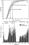
Human activities on land increase nutrient loads to coastal waters, which can increase phytoplankton production and biomass and associated ecological impacts. Numeric nutrient water quality standards are needed to protect coastal waters from eutrophication impacts. The Environmental Protection Agency determined that numeric nutrient criteria were necessary to protect designated uses of Florida's waters. The objective of this study was to evaluate a reference condition approach for developing numeric water quality criteria for coastal waters, using data from Florida. Florida's coastal waters have not been monitored comprehensively via field sampling to support numeric criteria development. However, satellite remote sensing had the potential to provide adequate data. Spatial and temporal measures of SeaWiFS OC4 chlorophyll-a (Chl(RS)-a, mg m(-3)) were resolved across Florida's coastal waters between 1997 and 2010 and compared with in situ measurements. Statistical distributions of Chl(RS)-a were evaluated to determine a quantitative reference baseline. A binomial approach was implemented to consider how new data could be assessed against the criteria. The proposed satellite remote sensing approach to derive numeric criteria may be generally applicable to other coastal waters.
Figures


Similar articles
-
Biogeochemical classification of South Florida's estuarine and coastal waters.Mar Pollut Bull. 2013 Oct 15;75(1-2):187-204. doi: 10.1016/j.marpolbul.2013.07.034. Epub 2013 Aug 19. Mar Pollut Bull. 2013. PMID: 23968989
-
Exploratory study of the Sentinel-3 level 2 product for monitoring chlorophyll-a and assessing ecological status in Danish seas.Sci Total Environ. 2023 Nov 1;897:165310. doi: 10.1016/j.scitotenv.2023.165310. Epub 2023 Jul 6. Sci Total Environ. 2023. PMID: 37422233
-
Maximizing the accuracy of field-derived numeric nutrient criteria in water quality regulations.Integr Environ Assess Manag. 2014 Jan;10(1):133-7. doi: 10.1002/ieam.1485. Epub 2013 Dec 16. Integr Environ Assess Manag. 2014. PMID: 24123826
-
A historical overview of coastal eutrophication in the China Seas.Mar Pollut Bull. 2018 Nov;136:394-400. doi: 10.1016/j.marpolbul.2018.09.044. Epub 2018 Sep 26. Mar Pollut Bull. 2018. PMID: 30509822 Review.
-
Coastal marine eutrophication assessment: a review on data analysis.Environ Int. 2011 May;37(4):778-801. doi: 10.1016/j.envint.2011.02.004. Environ Int. 2011. PMID: 21411155 Review.
Cited by
-
Spatio-Temporal Dynamics of Inherent Optical Properties in Oligotrophic Northern Gulf of Mexico Estuaries.Cont Shelf Res. 2018 Aug 15;166:92-107. doi: 10.1016/j.csr.2018.06.016. Cont Shelf Res. 2018. PMID: 36419821 Free PMC article.
-
Novel Analyses of Long-Term Data Provide a Scientific Basis for Chlorophyll-a Thresholds in San Francisco Bay.Estuar Coast Shelf Sci. 2017 Oct 15;197:107-118. doi: 10.1016/j.ecss.2017.07.009. Estuar Coast Shelf Sci. 2017. PMID: 30220764 Free PMC article.
-
Quantifying seagrass light requirements using an algorithm to spatially resolve depth of colonization.Estuaries Coast. 2018 Mar 1;41(2):592-610. doi: 10.1007/s12237-017-0287-1. Estuaries Coast. 2018. PMID: 30034302 Free PMC article.
-
Characterizing light attenuation within Northwest Florida Estuaries: Implications for RESTORE Act water quality monitoring.Mar Pollut Bull. 2017 Jan 30;114(2):995-1006. doi: 10.1016/j.marpolbul.2016.11.030. Epub 2016 Nov 19. Mar Pollut Bull. 2017. PMID: 27876374 Free PMC article.
-
Earth observations and integrative models in support of food and water security.Remote Sens Earth Syst Sci. 2019 Feb 11;2(1):18-38. doi: 10.1007/s41976-019-0008-6. Epub 2019 Mar 15. Remote Sens Earth Syst Sci. 2019. PMID: 33005873 Free PMC article.
References
-
- Peierls B. L.; Caraco N. F.; Pace M. L.; Cole J. J. Human influence on river nitrogen. Nature 1992, 350, 386–387.
-
- Rabalais N. N.; Turner R. E.; Sen Gupta B. K.; Boesch D. F.; Chapman P.; Murrell M. C. Hypoxia in the northern Gulf of Mexico: Does the science support the plan to reduce, mitigate, and control hypoxia. Estuaries Coasts 2007, 30 (5), 753–772.
-
- Howarth R. W.; Billen G.; Swaney A.; Townsend A.; Jaworski N.; Lajtha K.; Downing R.; Elmgren N.; Caraco N.; Jordan T.; Berendse J.; Frenet V.; Kudeyarow V.; Murdoch P.; Zhao-Liang Z. Regional nitrogen budgets and riverine N & P fluxes for the drainages to the north Atlantic Ocean: Natural and human influences. Biogeochemistry 1996, 35 (1), 75–139.
-
- Howarth R. W.; Anderson D.; Cloern J.; Elfring C.; Hopkinson C.; Lapointe B.; Malone T.; Marcus N.; McGlathery K.; Sharpley A.; Walker D. Nutrient pollution of coastal rivers, bays and seas. Issues Ecol. 2000, 7, 1–14.
-
- Steidinger K. A.; Vargo G. A.; Tester P. A.; Tomas C. R., Bloom Dynamics and Physiology of Gymnodinium breve with Emphasis on the Gulf of Mexico. In Physiological Ecology of Harmful Algal Blooms; Anderson D. M., Cembella A. D., Hallegraeff G. M., Eds.; Springer-Verlag: Berlin, 1998; pp 133–153.
Publication types
MeSH terms
Substances
LinkOut - more resources
Full Text Sources

